Neb "Dr. McCoy" Frye

I'm trying to get a topographical map generated so my Civil Engineer dad can do the road grade plan for the new Renaissance Faire site in Belfair, WA. No, Mason County does not have any decent topos of the very rural area. The site was leased from Pope Resources, a logging company, and they certainly never needed detailed plans of the site.
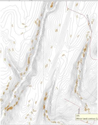
The screenshot on the left is a lovely topo I've managed to generate using about 65 different types of software that I've downloaded in the last month. Unfortunately, it's intended for use in a mobile GPS unit, so I have a .mp (polish) or .img (Garmin) file. They look lovely, but are pretty useless for AutoCad. I need a .dxf file. If there's software out there that can convert the above file types to .dxf, I haven't been able to find them. I can finds scores of them that will take a CAD file and covert it the other way, which is somewhat less than helpful.
I've sent The Draftsman (my brother) a .dxf of these contours that I generated with DemTopo, but it won't have the road on it.
Why does any of this matter? It matters because this site needs to have the Road Grade plan submitted in the next couple of days or the County, who have been very passive/aggressive about this project, will revoke the permits for the project.
No pressure or anything.
Hi,
ReplyDeleteTry to use this http://www.inkscape.org/, i haven't used it myself, but i heard it works well.
I usually insert the image in autocad (Insert --> Raster Image) and draw over it with polyline. To smooth it just edit the polyline and convert it to spline.
Hope i've been useful :)
You kids with your polylines and your splines! Thanks for the tip, I'll check it out and pass it along to the brains of the operation. :-)
ReplyDelete